Canard River, Tidal Floods, and Acadian Dykes
11 February, 2025 - Reading time: 6 minutes
A view of the Canard River before all the dykes were built .
-
Minas Basin Rivers before 1680 - Tidal Flooding
Today when one drives from Wolfville to Canning, Nova Scotia, it is a pleasant passage through productive farmland the whole way. During thetransit, there are crossings of a river and a couple small streams which are hardly noticed. Before 1750 this trip would have been far different because several dykes holding the tidal waters of the Minas Basin had not been built yet.
The map below of the area of interest shows the flooding to the 7 meter level which is the top of the current Wellington dyke. So the blue area would be covered in water at high tide if the dyke were not there..
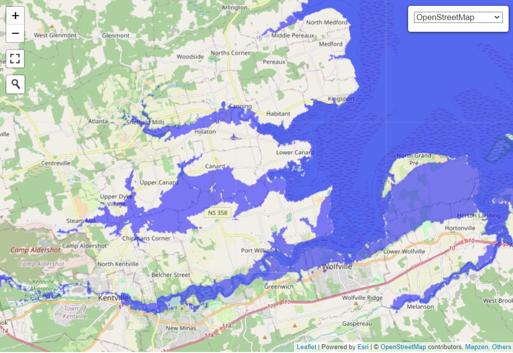
Wellington Dye and Lands
The Wellington dyke was build by the Planters in 1825 and preserved all the lands the Acadians had 'rescued' from the tides of the New Minas Basin plus marshes seaward of the road from Port Williams to Canard. The dyke is 1.8 km long and allows approximately 1300 hectares to be used for farming that would otherwise flooded periodically by salt water. The tides had pushed water up the Canard River past Steam Mill to north of Aldershot. The amount of farmland created is equal to and a little more than the land behind the Grand Pre Dykes.
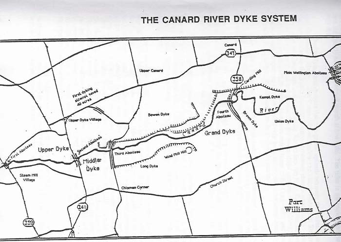
The Stages of Dyking by the Acadian Settlers
The land along the Canard River was 'rescued' from the sea in stages. The first dykes were a small one at Steam Mill that opened up about 20 ha for crops and another at Upper Dyke Village on a tributary of the Canard River that opened up about 25 ha.. The map below is one from Brent Fox's book "Wellington Dyke: History of the Canard River Dykes" published by the Kings Historical Society in 1985. The Acadian dykes, in order of construction were
- Upper Dyke Village
- Steam Mill
- Upper Dyke
- Middle Dyke
- Grand Dyke
Dyke Length and Area Added to the Farmland
The following numbers were determined using online mapping using Flood Maps and Google Earth.
| Name | Length (m) | Area Added (ha) | Area subtotal (ha) |
| Steam Mill | 90 | 17 | 15 |
| Upper Dyke Village | 250 | 25 | 40 |
| Upper Dyke | 520 | 95 | 135 |
| Middle Dyke | 540 | 130 | 265 |
| Grand Dyke | 1750 | 620 | 885 |
| Wellington Dyke | 1850 | 410 | 1295 |